At this section, the Amber Trail runs through the Middle Vistula Valley and the Wieprz Ancient River Valley Protected Landscape Area. This area is exceptionally abundant in numerous species of fauna and flora, and Piskory and Czapliniec Nature Reserves are located at the route of the trail. En route you can also observe how rich and diverse ecosystems coexist in the vicinity of large industrial plants.
Traversing the road to Dęblin, you will encounter many interesting traces of the stormy history of this land. You will have a chance to see historical monuments that until recently were known only locally, as well as monuments that are unique on a national scale. A visit in Europe’s only Museum of Unusual Bicycles will certainly be an unforgettable experience.
Almost the entire route features low vehicle traffic (except for a few sections where you need to be more careful). Although mountain bikes are not necessary for the route, as most of the roads have a paved surface; however, it will be very practical to have a bicycle equipped with gears on several sections of the route.
You begin the ride in the direction of Dęblin in Puławy at Bolesława Prusa Street, at the entrance to the municipal forest. The Amber Trail overlaps with the Puławy blue bicycle loop, which leads to the Piskory Nature Reserve, over the 17 km stretch. You set off on the bicycle path through the forest, you pass by a shelter less than 100 m into the forest, and about 2 km later you go on the overpass UNDER Długa Street (at 1.87 km). Further on, you continue along the mid forest gravel road until the dam bridge over the Kurówka River (at 2.25 km). Behind the bridge, the trail veers slightly right, toward the visible chimneys of the “Puławy” Nitric Acid Plant. You ride along the overpass UNDER the railroad tracks (at 3.19 km), and after climbing a few steps, you reach the asphalt road. After 200 m you turn left into Eugeniusza Kwiatkowskiego Street (at 3.43 km). You cross the bridge over the canals bringing water, indispensable for technological processes, from the Vistula River to the nitric acid plant (at 3.74 km). You reach the parking lot of the Prefabet Puławy Joint Stock Company and turn left onto the narrow gravel path that starts right behind heat distribution pipes that are located rather low.
You then face a longer ride along the railroad tracks in the northwest direction. First, you ride several hundred metres on the path, and then on the asphalt road near the railway overhead line until you reach the controlled level crossing (at 4.2 km). You cross to the other side of the tracks and then ride about 800 m along Budowlana Street, and turn right into the forest onto the forest dirt road (at 5 km). In the forest you turn right at the first fork road (at 5.17 km) and over 600 m later you turn left between the young birch trees. You continue straight on for about 6 km, initially through the forest along the railway tracks and then, right before the Puławy Azoty Railway Station (at 7.51 km), you enter the asphalt road that runs along the railway overhead line. Over 3 km later you reach the site where the yellow bicycle trail begins (at 11.09 km) that leads to Gołąb. According to the signpost, you are now 15 km away from Dęblin, 600 km away from Gdansk and 690 km away from the end of the Amber Trail on Hel. It is worth leaving the trail for a while in order to head west to the nearby village of Gołąb.
The yellow bicycle trail (7.3 km long) starts at the former Gołąb Railway Station. In the same village, the route runs through Krzywa, Puławska, Zamojska and Kolejowa Streets. You continue from here along Route 845 and ride through the village of Studzienice, until you reach the intersection near the level crossing.
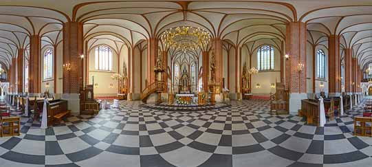
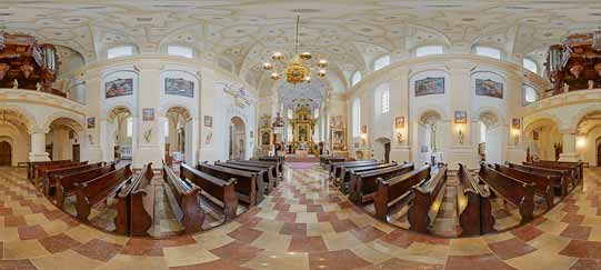
When in Gołąb, you should visit the Church of SS. Florian and Catherine located at Folwarki Street that was erected in the years 1626–38. It is an example of the northern Renaissance style that is very rare in the Lublin Region. It is interesting to know that the church was conceptualized and designed also as a defensive building. This explains why there are double brick walls above the arcades (the space between them is about 1 m long). While visiting the church, you can walk between the walls from the choir to the main altar. The oldest 17th-century part of the fence with the four loopholes also has characteristics of a fortress. Inside the church, the high altar dating from the 17th century, a Renaissance pulpit supported by two confessionals, and a Baroque pipe organ are particularly noteworthy. The local church is also the Sanctuary of Our Lady of Loreto, the patron saint of travellers.
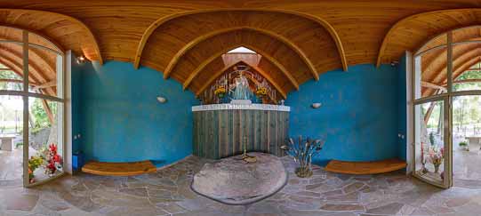
The nearby House of Loreto was built ca. 1640 thanks to the efforts of Father Szymon Grzybowski, as a copy of Santa Casa of Loreto. The construction was completed thanks to the revenue from the parish estate and tithes as well as from parishioners’ donations. The main founder of the church was Jerzy Ossoliński, who made a pilgrimage to Loreto in 1633, and made a vow that he would build a similar structure in the village of Gołąb. As a result, a two-storey building with a butterfly roof hidden behind the attic was constructed. Thanks to its rich sculpture ornaments, the building is a unique example of the late Renaissance architecture in the Lublin Region. Four portals are decorated with the bas-reliefs representing the Evangelists, while the niches feature statutes of prophets alluding to the art of Micheloangelo. The polychromes from the 17th century with the scenes of the life of Our Lady are of great artistic value. A faithful copy of the House of the Holy Family of Nazareth is placed inside the late Renaissance building. One of the walls features a window through which – according to legend – Archangel Gabriel entered the house in the last rays of sunshine and announced the great news to the Virgin Mary. In the 17th century, services were held in the House of Loreto, and the faithful eagerly left votive offerings here (according to tradition, the majority of the offerings went to Tadeusz Kościuszko in support to the insurgents). Later, the Swedish Invasion and the Vistula River flooding contributed to its gradual devastation. In 1720 the cracked walls were reinforced with iron anchor plates, and the chancel was supported with buttresses. The modernization and renovation works were also conducted in the first half of the 19th century, and the towers were added in 1856. The building was destroyed again during the Second World War, but currently, it has been restored to its former glory.
Visitors to the only Museum of Unusual Bicycles (ul. Puławska 1) in Europe can find out all there is to know about the history of single-track vehicles from the museum’s curator and simultaneously its founder, Józef Majewski. What is more, they can look at them and even try out recumbent bicycles, circus unicycles, as well as many other unusual vehicles powered by the muscle strength. Children and teenagers greatly enjoy riding on “galloping bicycles,” while the caring parents can give their kids a ride in a rickshaw. Museum is open from Apr 1– Oct 31, Mon-Fri 10am-6pm. It is possible to visit the museum at other times as well, after a telephone reservation in advance (phone: +48 601 814 527). More information is available at the website www.muzeumrowerow.pl. Another intriguing venue – Museum of Drunkenness – is located at the same address. It features a fascinating collection of diverse original alcohol bottles from all over the world. A rest area for cyclists is located right next to the two museums.
Nature lovers, too, will find something for themselves in Gołąb. The Vistula River section of high natural value is located in its vicinity, between the villages of Wólka Gołębska and Matygi. It is a nesting site of rare bird species, such as the Common Ringed Plovers and Little Terns. Both species have been listed in the Polish Red Book [of Endangered Species] of Animals. The local mid river islands on the Vistula River house nesting sites of other endangered species from the Charadriiforme family, like the Common Sandpipers, Common Terns, Little Ringed Plovers and Seagulls: Common Gulls, European Herring Gulls, and Black-headed Gulls. The high escarpments, bushes, and forested areas of the floodplain also feature nesting sites of other rare and endangered species, such as the Common Rosefinches, Remizes, Common Kingfishers, Sand Martins and Common Kestrels.
Continuing along the Amber Trail, right behind the road sign directing you to Gołąb, you reach an interesting wooden building of the Gołąb Railway Station (at 11.09 km), dating from the prewar period. It hides many truly intriguing mysteries...
During the Cold War, the military railway line between Puławy and Bąkowiec was established in order to ensure a strategic crossing over the river in case the railway bridge across the Vistula River in Dęblin was destroyed. A special pontoon bridge was supposed to facilitate the train crossing over the river and the military units of railway pontoon crossing regularly practiced setting it up. These practice manoeuvres, and the actual train crossing, took place for the last time in 1989. During that time, the bridge construction elements were placed on the fenced territory located behind the railway station building (between the building and the level crossing on the route between Gołąb and Niebrzegów). Following the fall of communism, the threat of the imperialist attack diminished and in the second half of the 1990s, when the Polish State Railways liquidated the Gołąb Railway Station, the secret railway posts were demolished and the bridge elements were removed.
Two spectacular partisan actions took place in the vicinity of the station during the Second World War.
On the night of May 12, 1943, partisans from the Puławy Branch of the Polish Peasants’ Battalions halted and attacked a German passenger train carrying soldiers going on holiday. As a result of the action, several dozen Nazi Germans were killed or injured.
The second partisan action, which literally echoed loudly in the region, involved blowing up an ammunition train several months later. On the night of September 12, 1943, partisans from the Puławy Branch of the Polish Peasants’ Battalions halted, attacked and then destroyed the entire train loaded with airplane bombs and rockets for the Nebelwerfer launcher. As a result of the action, seventeen Nazi Germans were killed. Two partisans and seven residents of Gołąb and Wólka Gołębska were slightly injured. Two engines and fifty-six fully loaded train cars were destroyed and the railway overhead lines were ruptured on the 200-metre stretch, which caused a 36-hour-long hiatus in the train traffic. Several buildings in Gołąb and Wólka Gołębska burnt down from the ammunition scattered in the vicinity by the explosion of the burning train. The same explosion was heard in the majority of Puławy County and it even triggered air-raid warning alarm in the Nazi German garrison in Puławy.
You turn right 900 m behind the Gołąb Railway Station (at 11.98 km) and head toward the village of Niebrzegów (where you again encounter the yellow trail leading to Gołąb). You cross the controlled level crossing (at 12.08 km) and head in the northwest direction. After about 1.5 km on the left, you pass by the Gołąb Mine that belongs to Lublin Mineral Materials Mine (at 13.66 km).
Extracting sand on an industrial scale has transformed the local landscape. If you want to see it, go behind the mine’s fence down the didactic path leading toward a high sand slope, from which you will have an excellent view of the borrow pits. One of them features a large water reservoir and the owner has transformed its vicinity into a protected area, similar to an ecological site.
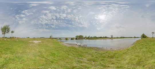
You leave the mine behind and after about 3 km, you reach a site where the blue trail and the Amber Trail part ways (at 16.7 km). The blue trail turns sharply right onto the field road (toward Nitric Acid Plant visible in the distance). You continue straight on along the Amber Trail on the asphalt main road, with the stream of the Wieprz River flowing nearby. According to the signpost, you are only 10 km away from Dęblin, and 3 km away from the Piskory Nature Reserve located on the blue trail.
The mid forest Piskory Lake and the Nature Reserve (area of 203.02 ha) are located within the borders of the Wieprz Ancient River Valley Protected Landscape Area. This place is exceptionally abundant in fauna and flora species. Thanks to the system of didactic paths with information boards presenting descriptions of birds and interesting facts from their lives, and special platforms facilitating animal watching, which have been created in the nature reserve, you can not only passively contemplate the local nature but also actively explore it.
Enthusiasts of rare animal species should visit Czapliniec Nature Reserve, located on the other side of the Amber Trail (also about 3 km away). You can encounter there the Grey Herons, after which the reserve is named [czapla in Polish], but also other birds, such as the Mallards, Smews, Common Goldeneyes, and Goosanders. Migrating birds, arriving both from Northern Europe and Asia, also stop here to rest, e.g. the Waders, Common Cranes, Geese and Storks.
You continue along the Amber Trail and several metres later you enter the village of Niebrzegów. On the right, you pass by a white roadside shrine ornamented with as many as 18 stars, but without a statue (at 17.35 km). The magnificent figure of St. Florian stands in front of the Volunteer Fire Department Station in Niebrzegów (at 17.62 km). You pass by the Chapel of Our Lady of Fatima from 1984 located on the other side of the road (at 17.67 km) and – also on the left – an information board with description of didactic paths designed by the Puławy Forest Inspectorate (at 17.98 km). It is worth stopping here for a while to learn about the offers prepared by the foresters.
You cross the bridge over the Wieprz River behind Niebrzegów (at 18.37 km) and enter the village of Bobrownik. Attention worthy is the modest roadside shrine dating from 1929 located at the entrance to the village, dedicated to Our Lady of the Holy Rosary. Two white little houses located behind it date from the same year.
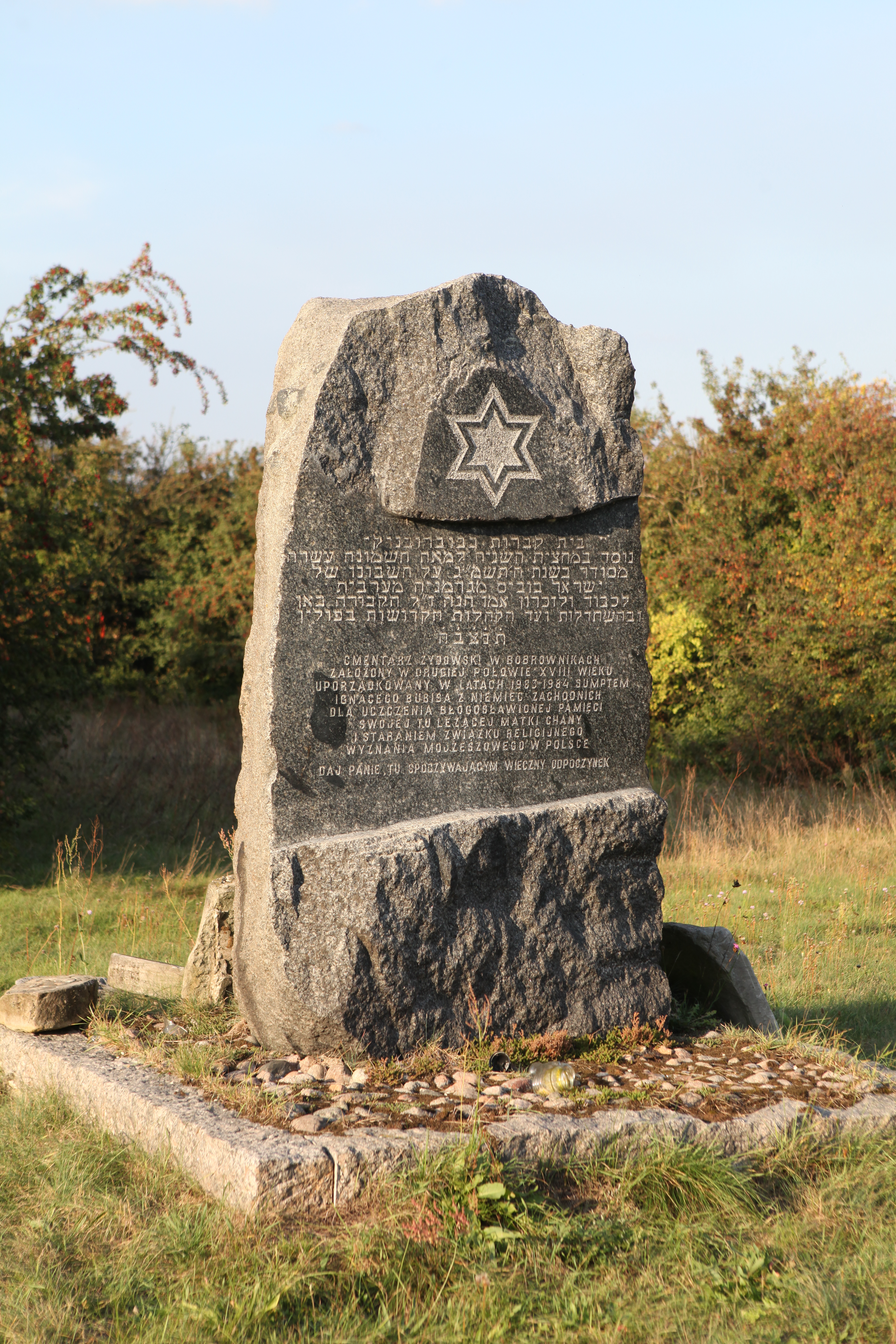
While in Bobrownik, you can visit a monument on the meadow adjacent to the Wieprz River, featuring the following inscription “In memory of people of this land, perished or murdered in the years 1939-1947.” The parish cemetery features interesting 19th-century tombstones with inscriptions in Russian, French and German. The remnants of the Jewish cemetery are also worth seeing.
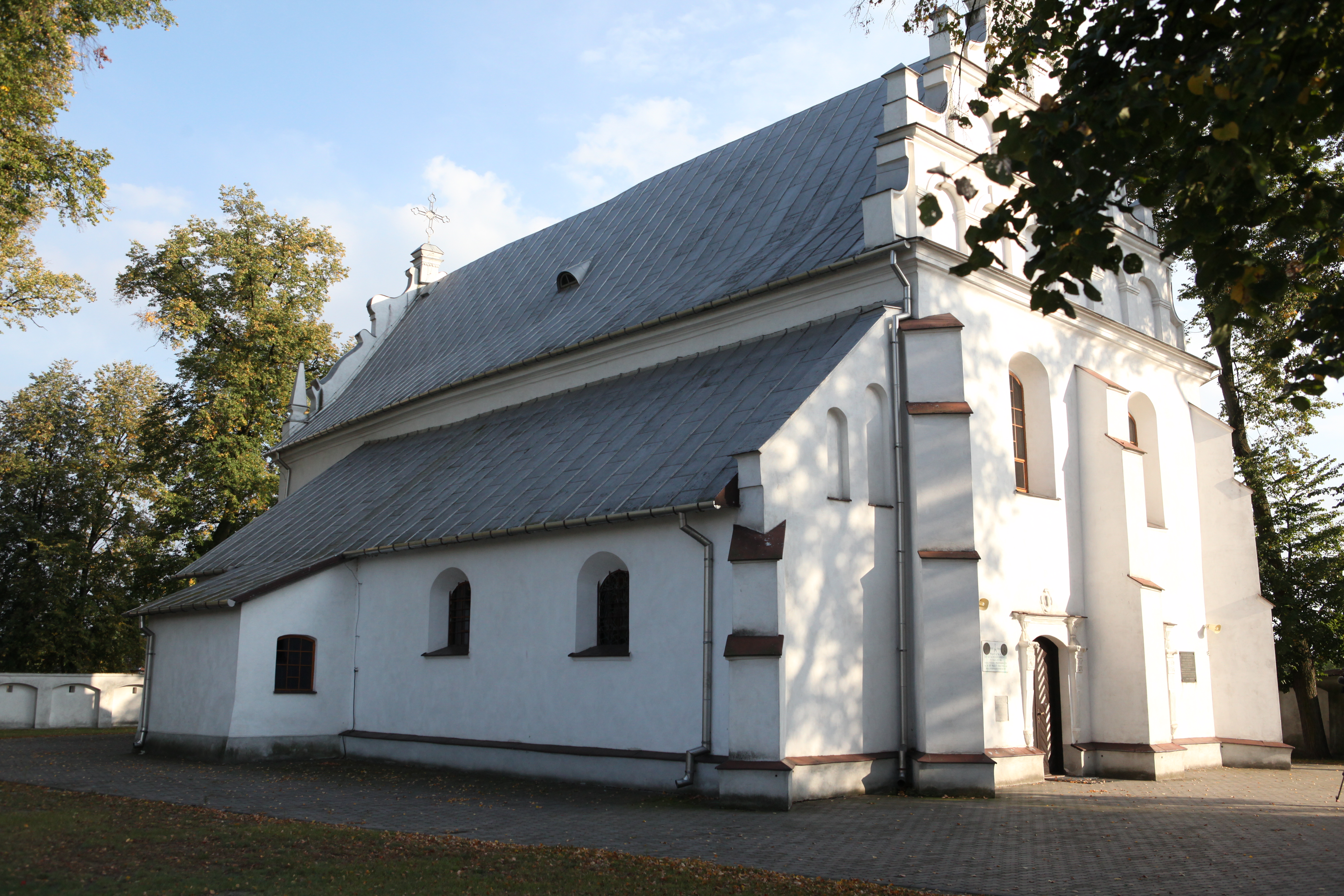
You pass by the historical Baroque Church of the Visitation of the Blessed Virgin Mary, which is over 500 years old, and then you turn left toward Dęblin. At the fork road you head right (at 19.2 km) and reach a place that turns into a wonderful flowery meadow in spring and in summer.
The meadows located in the close vicinity of the Wieprz and Vistula Rivers, as well as their oxbow lakes and riverside riparian forests are highly valuable habitats for many bird species. Meadows full of flowers also attract multitudes of insects, such as bees, bumblebees, butterflies, beetles and grass-hopers which are followed by larger animal predators who feed on them: amphibians, reptiles, birds or mammals. Meadows of the highest natural value are located at the Wieprz River in Obłapy, Nieciecz and Niebrzegów, in the Vistula River floodplain in the vicinity of Gołąb and in the Nur and Matyga Lake region. Research shows that it is a nesting site of many rare species, such as the Hoopoes, Corn Crakes, Western Marsh-Harriers, Common Kestrels, Great Crested Grebes, Mute Swans, Common Snipes and European Green Woodpeckers.
You leave Bobrownik behind (at 20.57 km) and reach the village of Kleszczówka. En route you pass by a roadside shrine dating from 1947 (at 21.74 km), and then a shrine dedicated to Our Lady of Fatima, founded in 1998 by the village residents and made by the local youth. You leave Kleszczówka (at 22.61 km) and about 1 km later you enter the forest, and then continue into Skotnickiego Street. You turn left (at 23.65 km) into Kocka Street, passing on the way the exit toward the airport (at 25.54 km).
This way you can reach not only the airport, but also the Polish Air Force Academy, also known as the School of Eaglets. The academy is linked with the tradition of interwar air force academies. In 1921 Minister of Military Affairs decided that the educational centre for the newly created Polish Air Force would be established in Dęblin. Truth to be told, the academy was founded in 1925 in Grudziądz, but it was transferred to Dęblin as soon as 1927 to the newly erected buildings. In 1928, as the Air Force Cadet Academy, the school commenced educating the cadres of officers, observers and pilots. During the Second World War, after the September resistance fights in Poland, Polish airmen fought in the West under the banner of the Polish Air Force. After the war, the educational activity resumed in the Air Force Officer Academy, which in 1968 was transformed into the (Higher) Air Force Academy (thanks to which the graduates received the engineer degree). After another reorganization, ensuing the regulation of the Council of Ministers of June 7, 1994, the Polish Air Force Academy was established.
The Air Force Museum in Dęblin is affiliated with the academy (ul. Dywizjonu 303 nr 12) open Apr 1–Oct 31 Tue 10am-3pm (individual visitors – admission free), Wed–Sat 10am-3pm, Sun 10am-6pm; Nov 1–Dec 21 Tue–Fri 9am–2pm. The open-air exhibition features over 60 airplanes and helicopters as well as other kinds of technical equipment belonging to the Air Force, including air-defence and radar systems. The indoor exhibition is divided into two parts. The first part describes the birth of the air force and its development during the First and Second World Wars; the other part is devoted to modern history. The exhibits include documents, maps, sketches, photographs as well as elements of small weapons and uniforms.
A 4.5-kilometre-long ride through Dęblin is ahead of you. Most of the route – up until the overpass – runs on the bicycle paths. After the airport exit, on the left you pass by very interesting former Jewish wooden houses that have deteriorated in the course of time (at 25.59 km). All the time you go straight on along Route 48, through Niepodległości and Warszawska Streets consecutively. You need to be especially careful before the overpass located over the road because of the higher volume of vehicle traffic. You walk the bicycle across the street and ride onto the overpass (at 27.07 km). After the overpass, you enter 15. Pułku Piechoty “Wilków” Street.
The “Grot” [arrowhead] English Oak grows at the nearby Podchorążych Street. This monument of nature is considered a symbol of the town of Dęblin and is also the winner of the “Tree of 2011” Polish National Competition. The oak is over 500 years old, 28 m high, and has the circumference of 608 cm. It is closely connected with the 19th-century history of the Dęblin Fortress construction, whereas in 1920 it witnessed the Polish-Soviet War. It is also believed to possess magical powers of fulfilling wishes: you need to place the left hand on the trunk and whisper the wish.
Continuing along the same road, 1 km behind the overpass, taking caution, you turn left into Saperów Street (28.09 km) onto the tract paved with small hexagonal concrete plates [trylinka in Polish] of low vehicle traffic volume. One of the entrances to the Dęblin Fortress is located here (the main entrance is located at the Lublin Gate from the direction of Podchorążych Street).
The Dęblin Fortress has survived until contemporary times in a fragmentary form. Fort II Mierzwiączka, some elements of the citadel and the ruins of Fort Wannowski have been preserved in a good condition. The remainder of the forts, although entirely devastated, gives you an idea of the former magnificence of the fortification. Almost nothing has been preserved from the barracks in Zajezierze, and Fort IV and Fort Gorczakowa have also been completely destroyed (a careful observer will note a port layout visible in the vicinity). Although traces of the former glory of the Dęblin Fortress have been almost entirely and irreversibly lost, it is still worth seeing the extant remnants. You can reach the fortification from Podchorążych Street (The Lublin Gate) or from Saperów Street. Sightseeing is possible after a telephone reservation in advance (phone: +48 601 817 048).
You pass by a military area on the left with the entrance gate to the engineering corps unit, and again reach the familiar Route 48, i.e. 15. Pułku Piechoty “Wilków” Street, where you turn left (at 28.64 km) toward the bridge on the Vistula River. A very picturesquely located rest area can be found on its right (about 200 m later) at the Municipal Culture Centre.
Turning right before the bridge across the Vistula River, you find yourself on the blue trail – the local Dęblin bicycle loop that is 11.63 km long. It leads among others to Fort II Mierzwiączka (at Lipowa Steet) and to the Balonna military cemetery (access from Balonna Street).
The very well-preserved Fort II Mierzwiączka is about 3 km away from the citadel. It was made of brick at the swampy area at Mierzwiączka Creek. In the late 1870s, in response to General Totleben’s motion, it was decided that the Dęblin Fortress should be modernized by reinforcing it with seven outpost forts, four of which were located on the right bank of the Vistula River, and three – on the left bank. The construction began in 1878. All forts were built on a pentagonal plan and all were similar in size and artillery equipment. The fundamental fort dimensions were based on the experiences from the Russo-Turkish War of 1877-1878. Every structure possessed two ramparts: lower – for the infantry and behind it, higher – for the artillery. The brick escarpment was hidden in the moat protected by scarp caponiers; each fort had crew barracks in the gorge of the fort and storage units.
The Balonna Military Cemetery with the area of 0.5 ha is located on the slope of General Zajączek Redoubt. It was established by the Austro-Hungarian army in 1915 and it functioned until 1918. In the interwar period, it served as the Dęblin garrison cemetery, which housed the Flying Training Centre, 15th “Wilki”[Wolves] Infantry Regiment and 28th Light Artillery Regiment in Zajezierze. The nearby village of Stawy housed the Main Ordnance Depot No. 2. The cemetery also features an obelisk commemorating the soldiers of the 15th “Wilki” Infantry Regiment.
You enter the bridge from which a splendid view unfolds north and south on the Middle Vistula River Valley. This is where your journey along the Lublin section of the Amber Trail Greenways comes to an end. The other end of the bridge is already on the territory of Mazowieckie Voivodeship. The first place encountered on the trail is the village of Zajezierze (at 29.87 km).
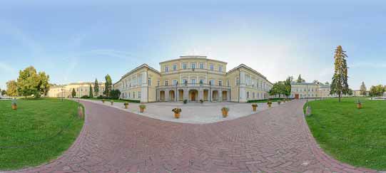
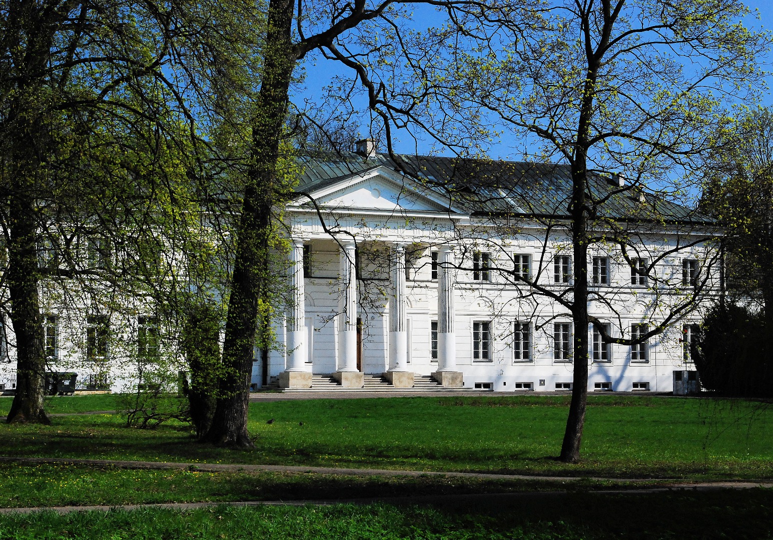
While in Dęblin, it is also worth following the black southern trail that is 3.95 km long. Proceeding along Spacerowa Street, you will reach the palace-park complex, designed by Jan Christian Schuch in 1779. Apart from monumental oaks, lindens and elms, the park also features the exotic cork oaks, as well as a pleasant pond with an island.
The short, merely 820-metre-long black northern trail runs along Dworcowa and Wiślana Streets and encompasses the noteworthy Nadwiślańska Railway Station Complex and the Church of Christ the Merciful.
The construction of the Dęblin railway station dates back to the 1870s and 1880s, while its reconstruction took place in the 1940s. The eastern part of the railway station is a wooden, one-storey building with timbering, built on an elongated rectangular plan, with two symmetrically placed garrets covered with the hip roof (the external and middle parts are covered with the pitched roof made of tinplate). The two-storey, brick western part of the railway station was also covered with the pitched tinplate roof.
Also worthy of attention are the former motive power depot and the railway management board office, also known as “Belweder.” Interesting residential buildings, originally designed for the families of higher-ranking railwaymen, are located in the immediate neighbourhood of the station. Three identical brick two-storey buildings of a villa type, covered with the mansard roof and featuring richly ornamented façades stand out in particular. Also worth noting is the historical technical equipment of the station, such as the “old” motive power depot dating from the late 19th century, and the “new” one, build in the 1940s, as well as two water towers, lattice bridge, signalling control, lineman’s house and water cranes.
Located slightly further down the road (ul. Wiślana 69), the wooden church boasts an interesting history. The building, dating from the first half of the 18th century, was initially located in the village of Łosice, and until 1878 it served as the Ukrainian Greek Catholic church. After the tsar liquidated the Ukrainian Greek Catholic parish, the church was taken over by the Roman Catholic parish. In 1929 Father Feliks Augustyniak, who strived to establish a parish in Dęblin, obtained a permission from the bishop, the parish priest, and the Roman Catholic parish council in Łosice to sell the no-longer-used former Ukrainian Greek Catholic church for 1,500 Polish złotych and to transfer it to Dęblin. On May 22, 1929, the bishop established the Parish of Pope Saint Pius V in Dęblin at 1 Maja Street. The church was expanded in 1960, and the adjacent new brick church was built in the years 1975–81. The old wooden church changed its location for the third time: in the years 1986–87, it was relocated to Wiślana Street, where the Parish of Christ the Merciful was established in 1986.

While in Dęblin, it is also worth following the black southern trail that is 3.95 km long. Proceeding along Spacerowa Street, you will reach the palace-park complex, designed by Jan Christian...
While in Bobrownik, you can visit a monument on the meadow adjacent to the Wieprz River, featuring the following inscription “In memory of people of this land, perished or murdered in...
During the Cold War, the military railway line between Puławy and Bąkowiec was established in order to ensure a strategic crossing over the river in case the railway bridge across the...
This way you can reach not only the airport, but also the Polish Air Force Academy, also known as the School of Eaglets. The academy is linked with the tradition of interwar air force...
On the night of May 12, 1943, partisans from the Puławy Branch of the Polish Peasants’ Battalions halted and attacked a German passenger train carrying soldiers going on holiday. As a...
Turning right before the bridge across the Vistula River, you find yourself on the blue trail – the local Dęblin bicycle loop that is 11.63 km long. It leads among others to Fort II Mierzwiączka...
The Dęblin Fortress has survived until contemporary times in a fragmentary form. Fort II Mierzwiączka, some elements of the citadel and the ruins of Fort Wannowski have been preserved in a...
The yellow bicycle trail (7.3 km long) starts at the former Gołąb Railway Station. In the same village, the route runs through Krzywa, Puławska, Zamojska and Kolejowa Streets. You continue...
The “Grot” [arrowhead] English Oak grows at the nearby Podchorążych Street. This monument of nature is considered a symbol of the town of Dęblin and is also the winner of the...